

Google Earth Engine’s web-based IDE is an unbeatable tool for rapid spatial prototyping and dataset exploration. However, when transitioning from exploratory research to building production-grade enterprise software, the Code Editor can become a technical bottleneck.
Whether you are automating daily satellite data ingestion, integrating geospatial ML models, or serving spatial insights to end-users without Google credentials, this guide covers how to scale beyond the IDE using the Google Earth Engine API. You will gain a clear roadmap on API authentication, commercial licensing, environment setup, and real-world backend architecture.
GEE Code Editor vs. GEE API
While both interfaces leverage Google Cloud’s server-side computation engine, they serve fundamentally different stages of the software development lifecycle:
| GEE Code Editor (IDE) | Google Earth Engine API | |
|---|---|---|
| Execution Model | Interactive, browser-based graphical platform (code.earthengine.google.com). | Programmatic, headless server-side pipelines (earthengine-api). |
| Language Support | Client-side JavaScript only. | Python & REST / Node.js JavaScript API. |
| Automation | Manual trigger (Requires clicking “Run”). | Fully automated via CRON, Airflow, or Cloud Functions. |
| Ecosystem Tools | Restricted to ee.* and ui.* namespaces. | Full integration with geopandas, rasterio, PyTorch, scikit-learn. |
| User Authentication | Google account approval required. | GCP Service Accounts for seamless server-to-server auth. |
| Query Constraints | Interactive limits (e.g., 10MB payload, short timeouts). | Enterprise quotas with batch compute and export tasks. |
Is GEE API Free for Commercial Use?
No, the Google Earth Engine API is not free for commercial deployments. While Google provides free access for academic, educational, and non-profit research, commercial projects require a paid Google Cloud Earth Engine subscription.
If you use Google Earth Engine for enterprise or commercial products, your overall costs depend on two main components:
- Base Platform Fee: A monthly platform tier subscription that grants project access, developer seats, and API quota limits.
- Usage Consumption: Pay-as-you-go billing based on the compute power used for processing (Earth Engine Compute Units or EECUs) and the data stored in Earth Engine.
For the most up-to-date breakdown on tiers and consumption rates, refer to the official Google Cloud Earth Engine Pricing Guide.
Get Started with Google Earth Engine API
By opting for the GEE API over the IDE, you can run satellite analysis pipelines headlessly at enterprise scale without hitting browser execution limits. Because both tools share the same underlying Google Cloud billing model, migrating your workflows to the API is a seamless technical shift.
If you already have existing JavaScript scripts in the Code Editor, ‘geemap’ can help you to directly translate GEE JavaScript syntax into Python code with minimal refactoring.
Step 1: Set Up a Google Cloud Project
Before calling the API, enable Earth Engine on your Google Cloud Platform (GCP) project:
- Go to the Google Cloud Console and create or select a GCP project.
- Enable the Earth Engine API under APIs & Services.
- Create a Service Account and download its JSON key file for server-to-server authentication.
Step 2: Select Your Environment
Choose the SDK that matches your production architecture:
- Python API: Best for data science, Jupyter Notebooks, and GeoAI workflows. Install via pip install earthengine-api geemap.
- JavaScript / Node.js API: Ideal for server-side web backends building real-time map features.
- REST API: Best for non-Python environments requiring direct HTTP requests for tile rendering or metadata queries.
Step 3: Learn the Core Concepts
Unlike traditional GIS libraries that download large files locally, Earth Engine methods run server-side on Google infrastructure. Master these core objects:
- ee.Image & ee.ImageCollection: For single raster tiles or multi-temporal satellite series (e.g., Landsat, Sentinel).
- ee.Feature & ee.FeatureCollection: For vector geometry, points, and administrative boundaries.
- ee.Reducer: For calculating spatial statistics (e.g., mean NDVI over a field polygon).
Step 4: Explore the Data Catalog
Instead of using the web UI, search and filter datasets directly within your code using unique asset IDs (e.g., ‘COPERNICUS/S2_SR_HARMONIZED’) combined with spatial (.filterBounds()) and temporal (.filterDate()) filters.
When Does the Code Editor IDE Still Make Sense?
While the API is the superior option for production software and backend automation, the IDE remains valuable for specific operational tasks:
- Standardized Script Sharing: Because the IDE runs in a standardized browser environment, scripts can be shared instantly via URL without dependency or environment setup issues.
- Instant Dataset Exploration: The built-in search bar makes it effortless to discover new public datasets and inspect metadata before writing pipeline code.
- Built-in Visual Inspection: The interactive map viewport and Inspector tool allow you to visually verify spatial calculations, test color palettes, and inspect raw pixel values instantly.
Production Case Study: Hunu’s GEE API Integrations
To see how the GEE API powers real-world mobile and web products, consider Hunu—the livestock tracking and pasture health platform built for Mongolian herders.
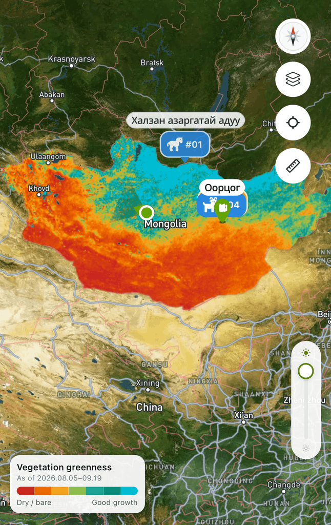
While Hunu validated its satellite remote sensing models (Sentinel-2 NDVI and MODIS Surface Temperature) inside the JavaScript Code Editor, launching a consumer mobile application required shifting entirely to the GEE REST API and Python backend infrastructure.
Key API Integration Features
1. Automated Server-Side Ingestion
Satellite data for Hunu is updated multiple times a day. Rather than forcing client devices to fetch raw rasters, an automated server pipeline uses the GEE API to query new Sentinel and MODIS tiles, compute biomass health scores, and cache optimized vector tiles server-side. Pre-processing and distributing map layers centrally ensures all herders instantly access fresh satellite insights without inflating API usage. Crucially, this server-to-server architecture delivers live spatial data seamlessly, eliminating the need to provide Google credentials of their own.
2. Offline Tile Caching for Remote Low-Connectivity Areas
Since connectivity across Mongolia’s grasslands is sparse, offline map functionality is vital. Using GEE’s batch export API, Hunu pre-renders grassland quality indices into lightweight vector tiles that download directly to the herder’s mobile device, ensuring full offline reliability.
3. Custom Mapbox Vector Rendering
While Google Maps is GEE’s native visual interface, Hunu utilizes Mapbox on the frontend for lighter mobile footprints and custom raster styling. The backend uses the GEE API to output processed image tile URLs, which are then rendered directly as custom layer sources inside Mapbox SDK.
While validating models inside GEE’s JavaScript IDE is a crucial first step, delivering those insights to end-user mobile devices necessitates the API. Much of Earth Engine’s spatial computation potential remains latent when confined to the browser IDE; transitioning to the API unlocks this capability, transforming static scripts into scalable, production-grade features.
Get Expert Help with Google Earth Engine
Building production-grade satellite applications requires moving beyond web-based prototyping to robust cloud architecture, automated ingestion pipelines, and custom GIS integrations.
If you need support scaling custom Earth Engine models, connecting GEE APIs to web applications, or optimizing Google Cloud infrastructure, reach out to our geospatial experts at Master Concept.


![[Free Webinar] Road to COP17: Unifying Enterprise Data with Planetary-Scale Geospatial AI](https://masterconcept.ai/wp-content/uploads/2026/09/Webinar-261007-Unifying-Enterprise-Data-with-Planetary-Scale-Geospatial-AI-_1280x720px-scaled.png)