

In recent years, “Smart city” has become one of the hottest buzzwords among public sectors and enterprises worldwide. But when it comes to truly making them work, one of the toughest challenges is road and traffic management.
Traditionally, urban traffic management has relied heavily on physical sensors, surveillance cameras, and even manual field surveys to update road information and adjust policies. This approach is not only expensive and limited in coverage, but also struggles to react quickly to sudden changes.This is exactly where Google Maps Platform’s Roads Management Insights (RMI) comes in!
Google has transformed its years of global mapping data and technology into a traffic management solution. With RMI, public sector, transportation departments, and infrastructure managers can now “let the data speak”, making smarter, faster decisions in urban planning, public safety, and disaster response.
What is Google Maps Roads Management Insights? What Data Does it Provide?
In simple terms, Roads Management Insights (RMI) is a data service built specifically for road and traffic management on Google Maps. It brings two core values to the table – Near-real-time traffic insights: Updates roughly every two minutes, giving cities a near-live view of road conditions. Long-term historical data: Stores up to 10 years of traffic data, providing a solid foundation for planning and research.
The key data RMI can deliver includes:
- Trip duration: Not just static distance, but actual travel time that accounts for traffic conditions.
- Speed reading intervals: Average speed across segmented road stretches, making it easier to pinpoint congestion hotspots.
- Bottleneck detection and traffic anomalies: Automatically flags when traffic suddenly slows down, helping identify accidents or unusual congestion.
- Peak-hour traffic patterns: Helps cities forecast demand and design road usage strategies for rush hours.
Unlike traditional traffic management systems that rely only on physical sensors to capture traffic at fixed points, Roads Management Insights (RMI) leverages anonymized location data from Google Maps users worldwide, processed by advanced algorithms. This means governments and public sectors can monitor road conditions in real time with far greater coverage and accuracy—without the cost and limitations of hardware-based infrastructure.

How Does Roads Management Insights Work? What Extra Traffic Data Does It Provide?
In the past, if a city wanted to monitor the condition of a specific road, it usually meant laying down hardware: installing cameras at intersections, embedding magnetic sensors in the pavement, running power lines, and maintaining on-site teams. While this setup could capture data, it was expensive, required constant maintenance, and only covered high-traffic areas.
Google Maps Roads Management Insights (RMI) completely changes that model. Instead of investing in physical infrastructure, RMI uses software and cloud services to transform massive streams of anonymized location data into actionable traffic insights.Turning “millions of daily trips on Google Maps” into a real-time health report for your roads.
RMI operates in three main steps:
- Route Definition
Public sectors or government organizations can first define which roads or corridors they want to monitor using the Roads Selection API. For example, they might specify “National Highway 1, Hsinchu to Taichung section” or “Zhongxiao East Road, Section 4, Taipei”. This ensures that data is targeted to priority routes, rather than diluted by city-wide averages. - Data Collection and Processing
Once routes are set, RMI begins gathering anonymized location data from Google Maps users. This information is automatically converted into average speeds, trip durations, and congestion patterns, with updates as frequent as every two minutes. Compared to traditional sensors—which require manual maintenance and often suffer from delays—this is practically a near-real-time traffic radar. - Data Delivery
- BigQuery: Stores and analyzes long-term historical data, with retention up to 10+ years for planning, research, and policy-making.
- Pub/Sub: Delivers real-time traffic streams, enabling traffic control centers to react instantly to unexpected events.
Exclusive Data Advantages of Google Maps Road Management Insights
Speed Reading Intervals
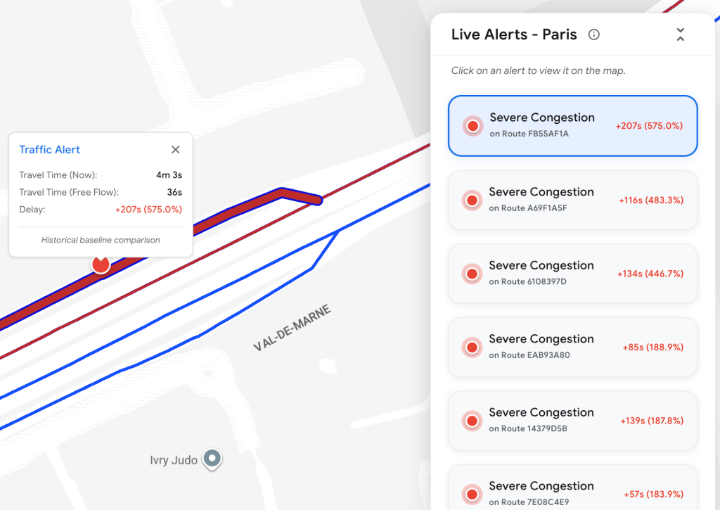
Traditional sensors can only tell you whether there’s “more traffic or less traffic.” RMI, however, breaks it down into where congestion starts, how long delays last, and exactly where they end. This level of detail is essential for identifying bottlenecks and designing detour strategies.
Dual-Mode Trip Duration
RMI provides both actual travel time under current traffic conditions and theoretical travel time if traffic were free-flowing. For example, if the theoretical trip from A to B is 15 minutes but the real trip takes 35 minutes, then the 20-minute gap is the true cost of congestion. This metric helps cities precisely identify which segments need urgent improvement.
In short, RMI goes far beyond answering “Is there traffic right now?”—it reveals the full context of congestion. From where it starts, how long it lasts, at what times it’s most severe, and how much extra commuting time it creates, the picture is crystal clear. For transportation agencies, urban planners, or public transit authorities, this kind of route-level health check is far more valuable than isolated traffic counts.
Why Roads Management Insights Outperforms Traditional Traffic Sensors
If you’re familiar with traffic management, you might wonder: “Cities already use cameras and sensors—why do we need RMI?” The difference lies in data sources, update frequency, and coverage.
| Metric | Traditional Sensors | Google Maps RMI |
| Data Source | Fixed-point sensors or manual surveys | Anonymized global Google Maps location data |
| Coverage | Limited to installation sites | City-wide, suburban, and even remote roads |
| Update Frequency | Minutes to hours; sometimes manual processing | Updates every ~2 minutes, near real-time |
| Data Type | Point-based traffic counts, speed at a location | Trip durations, speed intervals, congestion patterns |
| Setup Costs | High – requires hardware and ongoing maintenance | Cloud-based, no extra hardware needed |
Industries and Use Cases for Google Maps Roads Management Insights
A powerful tool like RMI is most valuable for sectors where traffic efficiency and real-time visibility directly impact outcomes. Here are some key applications:
Transportation Departments & Traffic Agencies
Move beyond relying solely on CCTV feeds. With RMI, agencies can adjust traffic signals dynamically and even predict congestion before it happens.
Example: A city like New Taipei could use historical RMI data to identify interchanges that see weekend traffic surges, allowing them to deploy officers proactively.
Urban Planning Authorities
Before building a new highway or arterial road, planners can analyze years of real commuting data instead of relying on simulations or assumptions. This makes urban development evidence-based and future-proof.
Public Transit Operators
Bus companies can leverage RMI’s speed intervals to pinpoint recurring delays between specific stops, enabling schedule adjustments that improve punctuality and rider satisfaction.
Infrastructure Managers
Instead of waiting for public complaints about chronic bottlenecks, agencies can use RMI data to prioritize road maintenance or redesign projects where they’re truly needed.
Emergency Response Teams
During disasters like earthquakes or typhoons, RMI instantly highlights which routes remain open, which are blocked, and where congestion is forming—helping ambulances and fire trucks save critical response time.

How to Integrate Roads Management Insights into City Traffic Systems
If you’re a city traffic decision-maker, you might wonder: “Can our existing traffic management system consume RMI data?” The answer is absolutely yes, and the integration process is straightforward:
If you’re a city traffic decision-maker, you might wonder: “Can our existing traffic management system consume RMI data?” The answer is absolutely yes, and the integration process is straightforward.
- API Integration: RMI’s BigQuery and Pub/Sub are standardized cloud APIs, making it easy to connect with existing platforms.
- Data Fusion: Combine RMI’s near-real-time traffic data with local sensors and CCTV feeds to create a comprehensive traffic picture.
- Intelligent Signal Control: Feed RMI data into signal management systems so traffic lights can automatically adjust based on current congestion levels.
- Incident Response: When RMI detects sudden speed drops (e.g., accidents), the system can trigger alerts and dispatch procedures immediately.
- Visualization & Decision Support: Integrate the data into a traffic control center dashboard so decision-makers can see changes in real time.
This integration doesn’t just make the system smarter—it empowers cities to make faster, data-driven, and precise traffic decisions.
Conclusion: Moving Cities from Reactive to Predictive
Traditional traffic management is often reactive, dealing with problems only after they occur. With Google Maps RMI, cities can move toward predictive traffic management. By leveraging vast amounts of near-real-time and historical traffic data, governments and organizations are no longer just responding to congestion—they can plan ahead and proactively optimize traffic flow.
Google Maps Roads Management Insights is more than just a data product; it’s a core tool for upgrading smart cities. If your business involves transportation, logistics, infrastructure, or public services, RMI offers a comprehensive, flexible solution that surpasses traditional traffic data approaches.
Reference Source:
https://developers.google.com/maps/documentation/roads-management-insights/overview
https://mapsplatform.google.com/maps-products/geospatial-analytics
https://blog.goodvisionlive.com/6-smart-cities-that-get-traffic-control-right
https://trellis.net/article/advanced-traffic-management-next-big-thing-smart-cities


![[Free Webinar] Road to COP17: Unifying Enterprise Data with Planetary-Scale Geospatial AI](https://masterconcept.ai/wp-content/uploads/2026/09/Webinar-261007-Unifying-Enterprise-Data-with-Planetary-Scale-Geospatial-AI-_1280x720px-scaled.png)